FIT File Routes
Routes are listed and described and the fit files can be downloaded to plan them and use in GPS directions. Note the fit files were generated in a Bryton GPS so they may not always be compatible with Garmin although they seem to work correctly in Strada.
Click on the route map or text of the route to download fit file.
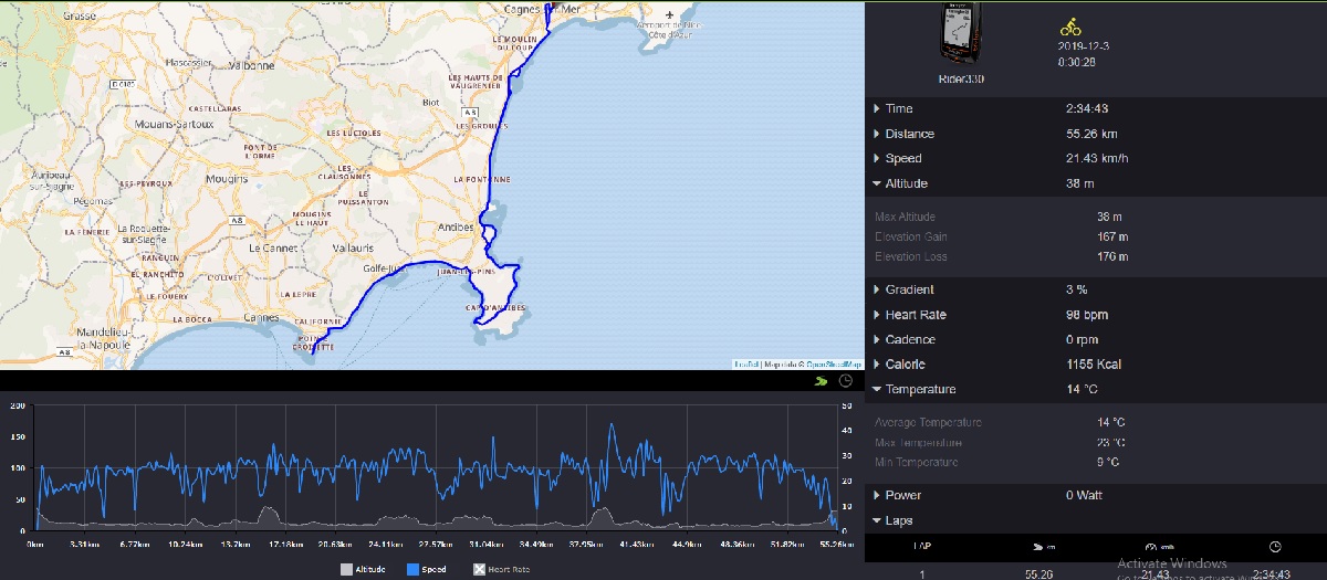
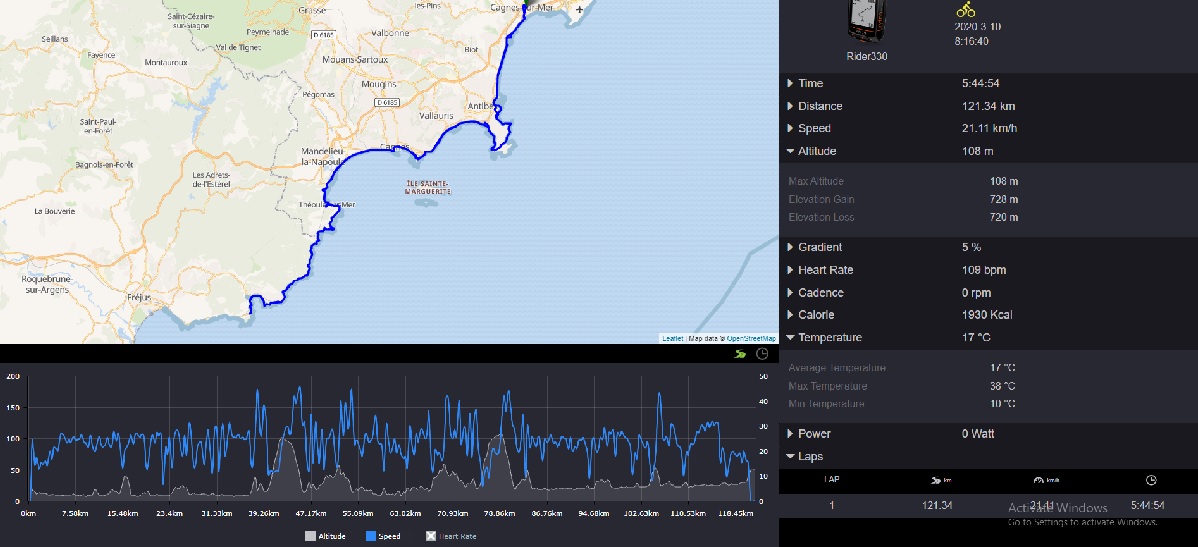 Cagnes-sur-Mer to Agay via Antibes, Juan-les-Pins, Cannes, Theole
Fit Route 001 Cagnes, Antibes, Cannes, Theole, Agay and return.
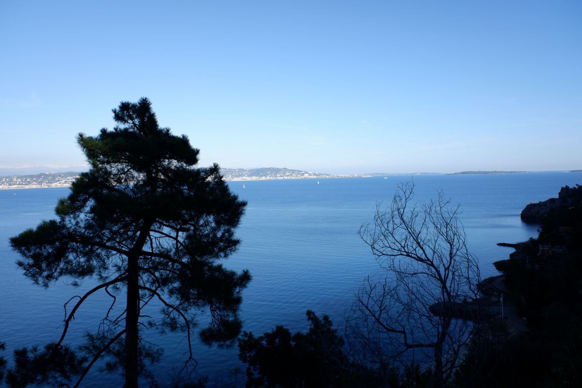
121.34km (75 miles), 728m (2388 feet) climbing, 720m (2362 feet) descent. This is a lovely route along the Estorel coast with magnificent views. It is best from Feb-May or Sep-Nov. Avoid Jun – Aug as there is too much traffic. Only busy part is Cannes. Although there is over 700m of climbing none of it is difficult. It is fairly long at 120km. At Agay there is a good bar/cafe/bakery that does good sandwiches/simple meals and drinks and you can sit outside. The actual route above was from about mid March. Note the massive difference in temperature from a minimum of 10°C(50°F) to a maximum of 38°C(100°F). The photos below are mostly from when the route was done in Late November. The temperature range was a minimum of 10°C(50°F) to a maximum of 31°C(88°F). Note with the low sun some photos show the road is still damp where no sun has reached it.
Click on the photo for a full size photo.
 Comfort break near Golfe Juan
 Croisette Cannes looking towards Juan-les-Pins and Cap d'Antibes
 Croisette Cannes pit stop for coffee
 Lunch break at Agay
 Scenery from lunch break at Agay
 View of the Esterel
 Plaque of Corniche route opening
 View of bay of Cannes from Near Theoles-sur-Mer
 View of bay of Cannes from near Theoles showing Lerin Islands
 Road near Theoles. Note it is still damp with no sun on it in the afternoon
 Cap D'Antibes near Eden Roc Hotel with President of the Cycling Club
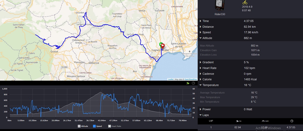
Click on the route map or text of the route to download fit file.
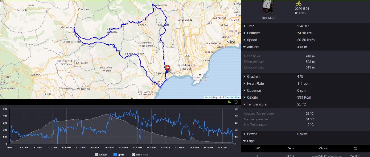
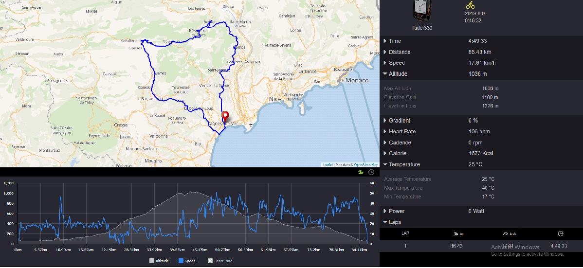 Cagnes-sur-Mer, La Colle-sur-Loup, Pont-du-Loup, Saint-Pons, Coursegoules, Bouyon, Carros, St Jeannet, Cagnes-sur-Mer
Fit Route 002 Cagnes, Villeneuve Loubet, La Colle-sur-Loup, Pont-du-Loup, Saint-Pons, Coursegoules, Bouyon, Carros, St Jeannet, Cagnes.
86.43km (53.7 miles), 1180m (3871 feet) climbing, 1226m (4022 feet) descent. This is a good hard ride with some magnificent views. From Pont du Loup (km 20) to Coursegoules (km 40) it is hard climbing with over 800m in the 20km with little let up. It is best from Apr-Oct. Avoid the winter as there is often cold and inclement weather. Take some wind protection for the descents and take care as there are some sharp corners in the descents with long drops if you run out of road! The actual route above was from about mid August. Note the massive difference in temperature from a minimum of 17°C(63°F) to a maximum of 40°C(104°F)
Click on the photo for a full size photo.


Click on the photo for a full size photo.
 Preparing the Tandem at Cagnes-sur-Mer
 Golfe-Juan, Napoleon Landed Here 1815 (01/03/1815 Napoleon landed here for the start of the 100 days which finished with Waterloo
 Golfe-Juan, Napoleon with some of his Field Marshals
 Golfe-Juan, Napoleon's Cavalry
 Golfe-Juan, One of Napoleon's Officers
 Golfe-Juan, some of Napoleon's footsoldiers
 Joséphine de Beauharnais with Maidservant
 Napoleon Banner
 Cap d'Antibes view of Antibes
 Cap d'Antibes, team waiting for me
 Route Antibes to Villeneuve Loubet looking towards Antibes
 Route Antibes to Villeneuve Loubet towards Villeneuve Loubet, note the sunbathers and snow on the mountains. Photo taken near end of April. It is possible to ski in the morning and sun bathe at the beach in the afternoon
 Route Antibes to Villeneuve Loubet with some local colour
 Arrival at Villeneuve Loubet with a view of Marina
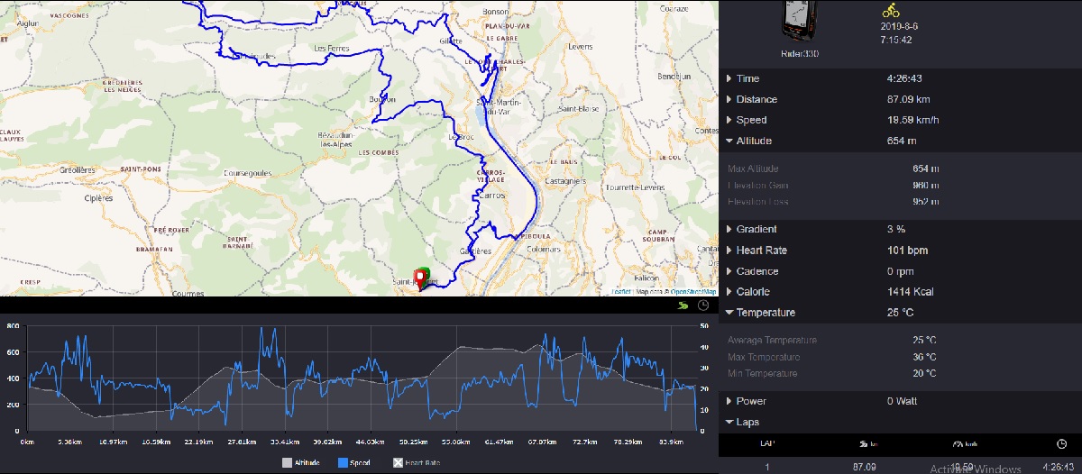
Click on the route map or text of the route to download fit file.
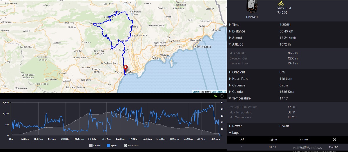
 Cagnes-sur-Mer, La Baronne, Saint-Martin-du-Var, Saint-Antoine, Les Moulins, La Baronne, Cagnes-sur-Mer
Fit Route 011 Cagnes-sur-Mer, La Baronne, Saint-Martin-du-Var, Saint-Antoine, Les Moulins, La Baronne, Cagnes-sur-Mer.
78.6km (28.8 miles), 706m (2316 feet) climbing, 723m (2372 feet) descent. This is a good ride with some beautiful views of the Var valley. It is best from Apr-Oct. Almost all the climbing is in the middle 20km
Click on the photo for a full size photo.
 After Bedoin Gerald Navas takes an early lead
 After Bedoin me following behind
 10km to the top with still at least 900 metres to climb
 About midway, Gerald is leading well
 About midway, me still well behind
 Pierre Kramer a casualty from 1983
 Gerald closing in on the summit
 Memorial to Tom Simpson who died here on Mont Ventoux 13/07/1967 on the Tour de France
 Tom Simpson Memorial Ride 50 years later
 Me closing on the summit, still well behind
 Me arriving at the top
 Gerald waiting patiently for me at the top
 Mont Ventoux summit with clouds beginning to roll in.
 Gerald and I prepared for the descent
 Malaucene after a safe descent